Monday, March 31, 2014

Chiricahua National Monument

Yesterday we visited Chiricahua National Monument.  The monument entrance gate is about 40 miles south of our campground at Willcox, Arizona.

The monument is strangely ;) in the Chiricahua mountains.  The mountains are termed a "sky island" - a 40 mile long chain of inactive volcano built mountains surrounded on all sides by desert.  The monument's rock formations were created by many layers of volcanic ash that unevenly hardend into rock.  The softer areas of ash were eroded away by wind and water. the enormous scale of the rock columns and pillars make for interesting photos.

I've uploaded a lot of photos which have been re-sampled to small scale to allow the pages to load faster.  Higher resoluton images can be seen on  my Flickr site.(http://www.flickr.com/photos/rjohnso3a/sets/72157643194371394/)


Here's a couple of videos from one of the highest overlooks in the park.


Wednesday, March 26, 2014

City of Rocks

Before departing the Alamogordo area on Tuesday, we spent an afternoon visiting the Space History Museum.  No pictures for the blog.  However, it is well worth the admission price; especially if you have school age kids with  you. 
It was a rather short 2 hour drive to our destination at the Dream Catcher Escapees RV park in Deming, New Mexico.  The road passes through the southern end of the Organ mountains.
We passed a Border Patrol checkpoint  while enroute.  They waved us on thru.  Generally they ask how many people are in the motorhome and if they are American citizens.  We have not been asked yet to allow then inside.  I guess we aren't very suspicious looking characters.
Deming is some 40 miles west of  Las Cruces.  The Escapees campground is basically a gravel parking lot, but has full hook-ups.  Most of the RV parks in this part of the country are like that.  Parks like this are nice as long as there is a sufficient amount of gravel to keep the dust to a minimum.  The Holloman AFB camp we had just left was much more dusty and needed an inch or two layer of large gravel.
After a good night's rest, we took care of some banking business at Wells Fargo in Deming and had lunch at a local restaurant.    Driving 22 miles north of Deming we found City of Rocks State Park.
The rocks of the park emerge from the floor of a desert valley of at lease 30 square miles. From a distance the park doesn't look too  impressive.  However, up close the rocks, most of which are as tall as a 3 story building, make for very interesting campsites.

 Walking among these monoliths makes one feel like you are in a natural stone henge.
It seemed as if it wouldn't be surprising to see cowboys or indians around the rocks.   This area has got to have been used to film some of the western movies I've seen in my childhood.


 It' too  bad we did not know about  this park before registering at the Deming RV park.


The Crimson Hedgehog cactus in bloom at the park's desert garden.

 Here is a video shot from a hilltop within the park.

Tuesday, March 25, 2014

Big Bend National Park


It's taken a while for me to get this posted due to the large number of photos.  On March 7th we visited Big Bend National Park.We had passed through the park the day before while enroute to our campground outside the park in Terlingua.  We planned to get some pictures at sunrise the next day.  Before dawn the next morning we drove toward  the southwest corner of the park toward Santa Elaina canyon.

After a 40-some mile drive in the dark through park, we arrived at  the canyon.  Santa Elaina is a very narrow canyon carved through 300 feet of rock vertical rock walls  by the Rio Grand river.  Unfortunately when the sun began rising, the heavy overcast prevented any direct sunlight on the canyon.


 When we were at the canyon entrance it was still too dark for good photos.  We slowly drove back toward the north.  Above are two distant photos of  the canyon entrance.

 As we traveled northward the sky began to brighten, but was still overcast.  In many shots I tried to capture the drama of the dark clouds against the colorful mountains.
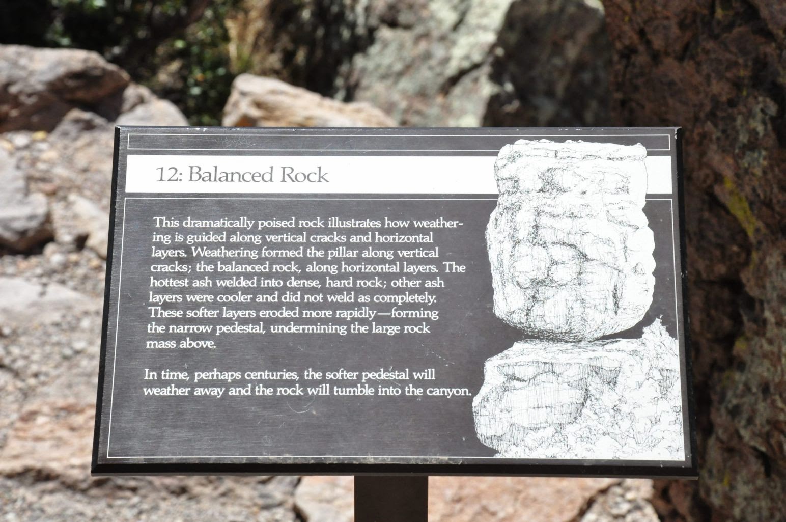
 Here a photo of the area called tuft canyon.  It is a narrow (almost slot) canyon carved by a small wash.  The source of the gray rock walls are layers of volcanic ash.  The area endured a lot of vocanic activity millions of years ago. 
 The peaks here are known as the mule ears.  One wonders why? :)
 And here's a sometimes mule headed character sitting in front of the mule ears.

 The park encloses completely the Chisos mountain range.  In the center of the range is the Chisos basin.
 The basin, at higher elevation than the rest of the park, and  therefore receiving more rainfall; has an environment which is more temperate than the surrounding desert.  After the basin, we decided to get some pictures of window rock (which appears in many park brochure  pictures).  The window is in an area called the Grapevine Hills.
To get to the window one must drive about 8 miles of rough gravel road, and then hike about a mile and a half on an "easy" trail. The trail was easy.  Easy that is for a teenager.  There is a rock scramble at the end which climbs several hundred feet.  We thought the rock formation above looked like a turtle's neck.

We thought the view was worth the effort.  The picture below was taken from nearby the window formation looking at the trail we had just traveled.

The arrow points to two other hikers who began the return hike soon after our arrival at the rock window.


 Ina on the return hike form the rock window
.


I'll close this posting with a nice shot of the road north from Santa Elaina canyon.  I'll upload all the pictures in this posting to our Flickr page.